Exploring Zealandia; New continent of the earth
By: Hamish Campbell
28th February 2019
28th February 2019
 |
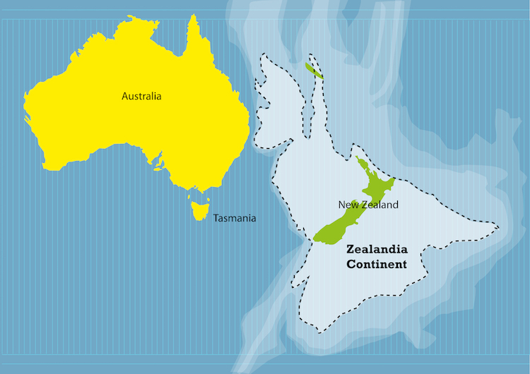
| Pictures shows the location of Zealandia in relative of Australia and New Zealand ; credit goes to Crystal Eye studio |
This talk on the discovery of this new continent is intrigue by the production of gravity based map where they noticed a significant part of the continents at Eastern and northern (New Caledonia) called Zealandia. Since then, more effort on discovering and understanding the part embarked by ocean journey of a group of scientist, called VESPA.
§ White erosion surfaces; flat surfaces
§ Bathymetric map based on gravity (Vaughan Stagoole, GNS Science 2002)
§ Showing shallow water around New Zealand
· Zealandia from Bruce Luyendyk 1995
* on the paper - Large continental crust exceed 10 million km and surrounded by oceanic crust
Earth’s most submerged continent.Thinnest, Smallest, Freshest but not the youngest; Australia and Antartica are the youngest. Highlighting the basalt, granite presence, differences in the elevation difference of oceanic crust and continental crust above sea level. Southern Zealandia; the largest continental crust on the pacific plate
In exploring the Zealandia, the focus has always been on the belt of schist in the southern Zealandia, consisting of Greywacke schist, Granite, diorite, gabbro. Sedimentary basins of the Zealandia is now being explored greatly.Recording the event of opening of tasman sea and another sea in the southern part. Part of the Drilled, terrain and supergroup are the. Schist island; in the middle of of pacific island and also the Pitt island; waihere bay; Tuuangi formation.
Result of the Expedition
Ø Eocene to pleocene age submarine volcano emerged underwear in the oast
Ø Southern chatham;
Ø Initially above water, due to extension submerged, the pushed back up
Ø New Caledonia; VESPA VOLCANIC EVOLUTION OF SOUTH PACIFIC ARCS
Ø Mostly basalt are found in the voyage, little andesite
Further information of Zealandia;
No comments:
Post a Comment